Flies you into the airport that's actually cheap, then tells you honestly whether the train ride from there is worth it.




Try it live: hopandhaul.munzzyy.dev. No install, no keys, runs entirely in your browser.
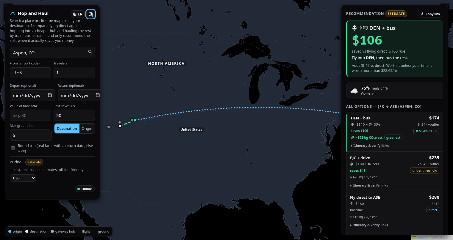
Click anywhere on the map and a recommendation card slides in: cost, time, and a CO2
estimate for every option side by side. A copy-link button turns the plan into a URL you
can send someone. That's a live screenshot, not a mockup: click a destination in the app
above, or run it locally with no API keys (about 30 seconds, below), then open
http://127.0.0.1:8770/?lat=39.1911&lng=-106.8175&place=Aspen,+CO&origin=JFK
to reproduce a trip like it.
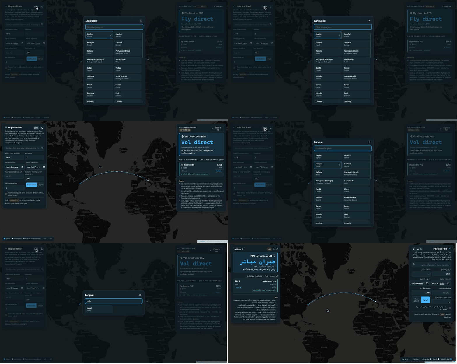
20-second demo: plan a trip, switch the UI to French, then flip the whole layout to Arabic:
Sometimes the cheapest way to get somewhere isn't flying there directly. It's flying into a nearby hub where flights are cheap and plentiful, then covering the last leg by train, bus, ferry, or rental car.
Google Flights and Kayak will search nearby airports for you. None of them tell you whether the split is actually worth it once you account for the extra hours. Rome2Rio will show you every possible multimodal combination between two points, but it doesn't tell you which one actually beats flying direct. Hop and Haul does exactly that one thing: prices the direct flight, prices every reasonable fly-into-a-cheaper-hub-then-ground alternative, and applies one rule.
The $200 rule: only recommend the split if it saves $200 or more (this is a flag, change
it), unless the split is flatly better on both cost and time, or the extra hours are worth it
at your own stated value of time (--vot, $/hour).
If a split doesn't clear that bar, it recommends flying direct, even if the split "technically" saved money. Marginal savings for hours of your day isn't a deal, and the tool says so instead of just showing you the cheapest number.
Not a booking site. It points you at the real flight/train/bus booking pages and stops
there. Not a price-prediction or buy-or-wait tool. Not a points/miles optimizer. Not a
hidden-city fare finder. No AI in the runtime path: the recommendation is deterministic math
you can read in trip.py, not a model's guess.
hopandhaul.munzzyy.dev is the whole app, running client-side on GitHub Pages. Nothing to install, no keys, no server. It's the same estimate engine ported to JS, and CI holds the port to exact numeric agreement with the Python one.
pipx install hopandhaul
hopandhaul-serve
(pip install hopandhaul works the same if you'd rather not use pipx.)
Then open http://127.0.0.1:8770 and click anywhere on the map. Or skip the map entirely:
hopandhaul go JFK "Tallinn" --date 2027-06-15
No API keys needed for any of that. Weather, place search, real ferry routes, real US fare data, and real ground-transport timetables all work out of the box, from the free sources listed below. A Duffel key adds live airfares; nothing else needs one.
Hacking on the code instead? Clone and dev-install:
git clone https://github.com/munzzyy/hopandhaul
cd hopandhaul
pip install -e .
What changed in each version is in the release notes.
Visiting several cities on one trip? hopandhaul multicity works out a good order to hit
them in, pricing every leg with the same fly-cheaper-hub-then-ground logic and $200 rule as
everything else here, then prints the ordered itinerary and a total:
hopandhaul multicity --home JFK --visit "Aspen,Boston,Chicago" --threshold 50
MULTI-CITY TOUR: JFK -> BOS -> ORD -> ASE -> JFK
round trip, 4 stops, solved via held-karp (exact)

ITINERARY:
  1. JFK -> BOS      $70    1h30  direct     (fly $70)
  2. BOS -> ORD     $105    3h06  direct     (fly $105)
  3. ORD -> ASE     $139    8h36  multimodal (fly $105 + bus $34)
  4. ASE -> JFK     $174    9h54  multimodal (bus $34 + fly $140)

TOTAL: $488 across 4 legs
Those Aspen legs are the point: at a $50 threshold, flying into Denver and taking the posted
$34 Bustang fare the rest of the way beats a direct flight, so the tour routes through DEN
instead of pricing every leg as a straight flight. --open ends the tour at the last stop instead of
looping back home, and --travelers N scales group costs the same way the rest of the
engine does. Up to about 9 cities it solves exactly (Held-Karp); past that it switches to a
nearest-neighbor-plus-2-opt heuristic and says so in the output.
Every other command here prices one --date. hopandhaul dates checks several at once and
tells you which one wins, pricing each candidate the exact same way hopandhaul duffel
prices a single day. Nothing is reimplemented, it's the same engine called once per date:
hopandhaul dates --from JFK --to ASE --date 2027-06-15 --window 3 --auto-gateways
CHEAPEST DATE SWEEP: JFK -> ASE
anchor 2027-06-15 +/- 3 day(s) (7 date(s) checked; dates already past are skipped)

   2027-06-12       $610     6h12   live       Fly direct to ASE
   2027-06-13       $590     6h12   live       Fly direct to ASE
   2027-06-14       $605     6h12   live       Fly direct to ASE
 → 2027-06-15       $455     8h54   live       DEN + bus
   2027-06-16       $620     6h12   live       Fly direct to ASE
   2027-06-17       $640     6h12   live       Fly direct to ASE
   2027-06-18       $600     6h12   live       Fly direct to ASE

CHEAPEST: 2027-06-15 - $455 via DEN + bus (live-priced)
With a DUFFEL_API_KEY set, every date is a real fare lookup. With no key, every date runs
through the same calibrated distance estimate the rest of the tool falls back to. Either way
each row is tagged with its basis: live, estimate, or mixed for a date whose
recommended option has one flight leg priced live and another (a thin gateway route Duffel
has nothing for that day, say) fell back, so a model number never gets mistaken for a
checked fare. The window centers on --date, 3 days each side by default, --window caps
out at 7, so a plain run won't fire off dozens of live lookups by accident. Repeat or
overlapping sweeps ride hopandhaul duffel's own per-date cache, so checking the same date
twice costs nothing extra. --return-date shifts along with each candidate departure, so a
round trip's length stays fixed while its placement in the window moves. Takes the same
--gateway / --auto-gateways / --adults / --cabin / --nonstop / --threshold /
--vot flags as hopandhaul duffel.
The map UI does the same thing. Put a date in and a strip of chips appears under the
recommendation, one per day in the window, each with its own price and its own basis tag.
Click one and the plan re-runs on that date. It is served by GET /api/dates and it runs
client-side on the Pages build too.
One rule worth knowing about, because it changes what you see: a window is priced all-live or all-estimate, never a mix. If the live pass runs out of rate-limit budget partway through, the whole window is thrown away and re-priced offline rather than leaving you comparing three real fares against four modelled ones. A window like that reports the cheapest day as a hint rather than a fact, and the UI declines to crown a winner. Days already in the past are dropped from the window instead of priced, since the fare model has no booking-lead-time curve to read backwards and would quietly price them like no date at all.
More of this tool is real data than you'd guess for something with zero keys:
- Ferry legs are real routes. The engine ships a researched database of 85 passenger-ferry corridors: actual ports, operators, crossing times, sailing frequencies, and fare bands checked against operator/aggregator pages (each entry cites its source and date). A boat only appears if it exists: there's no Helsinki-to-Tallinn train over the Baltic here, and no ferry to Maui, because there is no ferry to Maui.
- Ground-transport schedules are real timetables when Transitous (a community-run journey planner over worldwide GTFS, keyless) knows the route: real operators, real departures, real door-to-door times, labeled "live schedule" per leg. Fares on those legs are still estimates, because schedules are open data and ticket prices mostly aren't.
- US fares are anchored to what passengers actually paid. The bundled BTS Consumer Airfare Report extract (public domain, currently 2025Q2-2026Q1) carries real average fares for ~4,300 US city-pair markets; the model is clamped into each route's real band, and the itinerary shows the real market numbers next to the estimate.
- The base map is self-drawn, not fetched. Land, lakes, and borders are rasterized from bundled Natural Earth 1:50m geometry, themed to match whichever of the 8 UI themes is active, with zero tile requests and no watermark. An opt-in "detailed map" layer streams real OpenStreetMap raster tiles once you turn it on, and falls back to the drawn map automatically if that connection drops.
- Live airfares (Duffel): actual priced itineraries when you set
DUFFEL_API_KEY: real carrier, flight number, and clock times, labeled "live" instead of "example." No key falls back to the labeled estimate automatically. (The old Amadeus fallback is gone: Amadeus shut its self-service API down in July 2026.) - Everything else is a labeled ESTIMATE: a deterministic formula (distance, route-market
competition, airport size, booking date) calibrated against real fares. Every estimate says
so:
"pricing_source": "estimate"in the API, plain English in the UI, per-leg provenance in the itinerary. It's a model, not a promise; verify before booking. - The last mile is priced too, not assumed away. An airport is a stand-in for the place you actually clicked; when the two are more than 12km apart, every option (the direct flight included) prices a real final ground leg from the airport onward to that point. Where no honest way to cross the gap exists, the tool says so instead of inventing one.
- Weather (Open-Meteo) and place search (Photon) are real, live, and keyless. A Geoapify key upgrades search to full address-level geocoding if you want it.
- Every priced option shows its work: a leg-by-leg itinerary with real airport names, an example clock schedule (or the real one, once a live fare is priced), what each leg's price is based on, and a one-click link to check it, Google Flights for a flight leg and Rome2Rio for ground. No number without a way to check it.
- Boats, honestly: real ferry corridors as first-class legs (fly to Athens, take the real Blue Star boat to Santorini), and a land/water grid that stops the engine from routing a train across open sea when no bridge or tunnel exists
hopandhaul go A Bruns the whole pipeline in one terminal command, zero keyshopandhaul multicityorders N cities into one trip (exact for small N, a nearest-neighbor + 2-opt heuristic beyond that), reusing the same split-vs-direct pricing leg by leghopandhaul datessweeps a bounded window of dates and finds the actually cheapest one to fly, live-priced when a Duffel key is set, labeled per date so you know which- Deterministic split-vs-direct engine with the $200 rule (configurable threshold and value of time)
- Group-aware costs (per-person fares scale by travelers; a rental car scales per-vehicle
instead,
ceil(travelers / 4)cars, priced and said so) - Round-trip aware (real return pricing when the provider supports it, a stated estimate otherwise)
- Gateway discovery: curated hub suggestions plus geometric fallback search, worldwide, on both ends of the trip (a remote or expensive origin gets split options too, not just the destination)
- Every option prices the actual point you clicked, not just the airport: a final ground leg covers the gap when your destination is meaningfully far from its airport
- Click-anywhere map UI (Leaflet self-hosted; the base map is drawn from bundled Natural Earth geometry, zero tile servers, works fully offline; an opt-in "detailed map" layer streams real OpenStreetMap tiles only once you turn it on)
- An Online/Offline status chip next to the pricing badge (Auto/Online/Offline) tells you plainly what the app is allowed to reach; offline mode skips every external request and sticks to bundled data
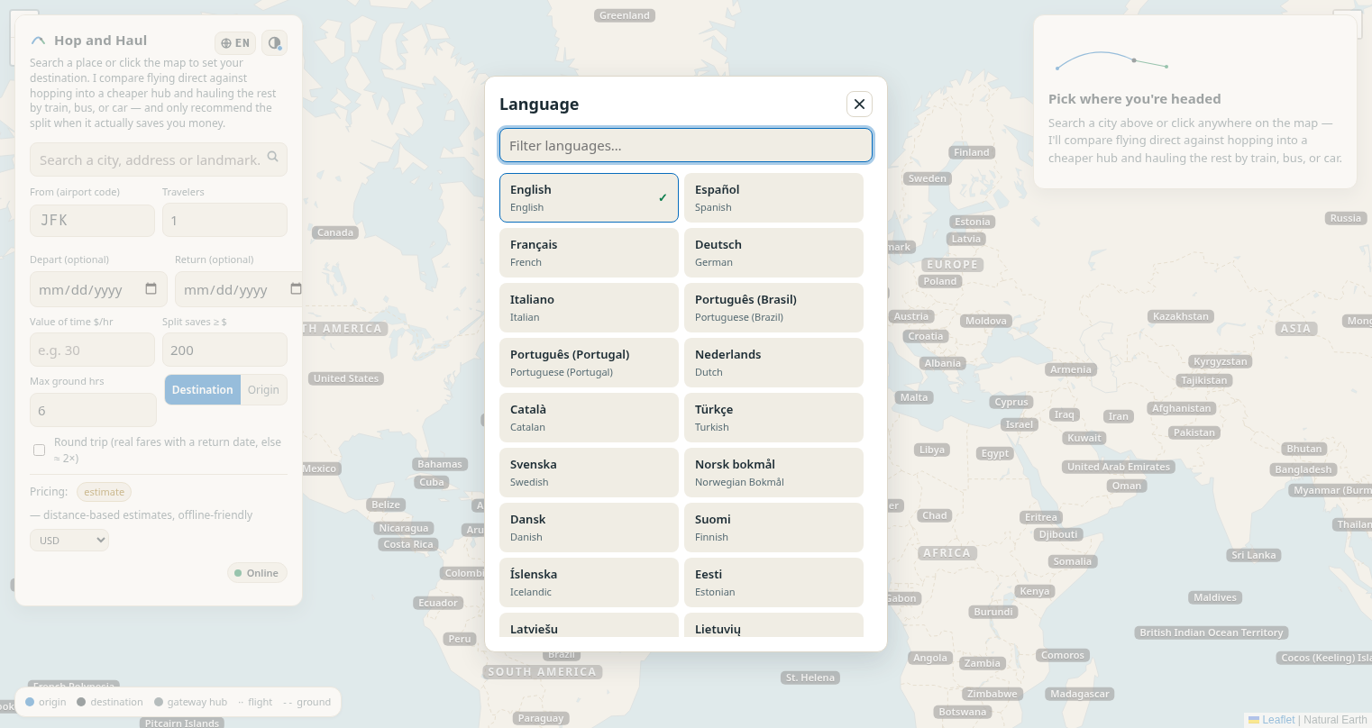
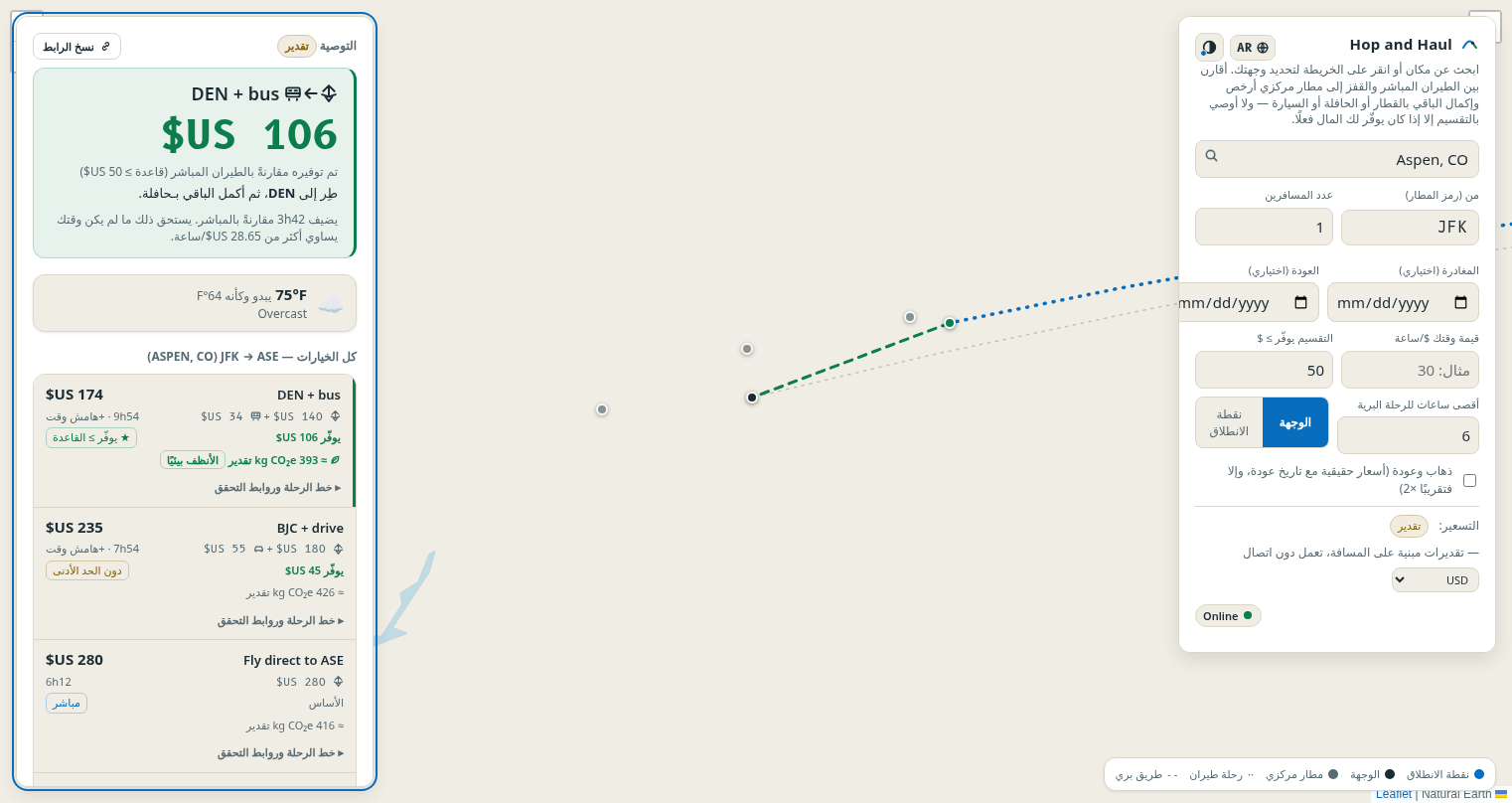
- UI in 46 languages, four of them fully right-to-left, behind a hand-rolled i18n runtime instead of a framework. Pick yours from the globe button
- Eight themes plus Auto, picked from the header: Departure Board, Boarding Pass, Night Flight (OLED), a CRT-amber Terminal, High Contrast, Rail Poster, Old Map, and Coastal
- Destination weather for the date you're planning
- Cheapest vs greenest: a rough CO2 estimate per option, with the lowest-carbon one flagged separately from the recommendation. Estimates, not a certified footprint, and never used to pick a winner for you
- Zero runtime dependencies: pure Python standard library, no
npm install, no build step
The whole UI ships in 46 languages: the big ones, plus Catalan, Icelandic, Swahili, Filipino, and both Chinese scripts. Arabic, Hebrew, Persian, and Urdu mirror the entire layout right-to-left, map panels included. Detection follows your browser, your pick sticks in localStorage, and a language whose catalog fails to load falls back to English instead of breaking.
 |
 |
Native speaker and you spot something off? A translation fix in
src/hopandhaul/ui/i18n/<code>.json is about the friendliest PR there is.
The web UI has its own display-currency selector now (USD by default): live daily ECB rates
from frankfurter.dev when the app is online, a bundled approximate
table offline, labeled which one is in use. The CLI commands (go, duffel, multicity,
dates) take the same idea as --currency EUR (or GBP, JPY, INR, and most other world
currencies) to print the report in that currency instead. Either way, the $200 rule and every
internal comparison stay in USD; only the final printed number changes:
hopandhaul go JFK "Tallinn" --date 2027-06-15 --currency EUR
trip.py: the $200-rule math. Given a set of priced options, decides what to recommend and why.geo.py: the estimation model. Nearest airport, gateway discovery run symmetrically on both origin and destination (so a remote/expensive origin gets split options too), the final-leg ground calculation for the actual clicked point, and the distance-based fare/ground formulas.itinerary.py: turns a priced option into a leg-by-leg timeline with real airport names, an example (or, with a live fare, real) clock schedule, per-leg price provenance, and a verify link. No invented flight numbers, no fake departure-time precision, no pretending a longitude-based guess is a real timezone. See the module docstring for the honesty rules.duffel.py: live flight pricing (optional key).flights.pyis the thin interface server.py talks to.dates.py: sweeps a bounded window of dates throughduffel.py's ownbuild_and_evaluate(), one call per candidate date with no separate pricing logic, and reports whichever one is actually cheapest.transit.py: real ground schedules via Transitous (keyless).places.py: place search, Photon by default (keyless), Geoapify when keyed.weather.py: Open-Meteo (keyless).go.py: the one-shot CLI. Resolve places, plan, print the report and itineraries.multicity.py: the multi-city tour optimizer. A plain TSP solver (Held-Karp, exact, for small city counts; nearest-neighbor + 2-opt above that) over a cost matrix built by pricing every leg throughgeo.py/trip.py, the same waygo.py/server.pyprice one.server.py: the stdlibhttp.serverapp. Serves the UI and the JSON API, nothing else.ui/atlas.js: the self-drawn base map, a LeafletGridLayerthat paints land, lakes, and borders on a canvas tile from bundled Natural Earth geometry instead of a raster tile server, themed per UI theme.ui/map.jslayers an opt-in OSM detail tile layer over it, requested only once you turn it on, with an automatic fall back to the drawn map if that connection fails.ui/connectivity.js/ui/netchip.js: the explicit Auto/Online/Offline mode and its status chip. Offline (forced, or auto-detected via the browser's own online/offline state) gates every external fetch inui/api.js/ui/transit.js, so live schedules, extended place search, weather, live FX, and the OSM detail layer honestly announce they need a connection instead of silently retrying.ui/fx.js: the web UI's display-currency conversion, mirroringduffel.py's FX table as the offline fallback and upgrading to a live daily ECB rate from frankfurter.dev when online. The $200 rule and all internal math stay USD; this only changes what gets printed.ui/sw.js: the PWA service worker. Boots a shared deep link while offline, keeps downloaded language catalogs cached across app updates, and gets its cache name stamped with the commit SHA on every Pages deploy.data/: the bundled real-world datasets. 4,175 airports (OurAirports), 85 ferry corridors (researched, sourced per entry), a 0.25° land/water grid and the basemap geometry (both Natural Earth), and real US market fares (BTS).tools/has the scripts that regenerate them.
Every one of these is a plain, readable module you can open and check the reasoning of, not a
black box. See docs/api.md for the exact HTTP contract.
Every module ships an offline self-test. No keys, no network, under 20 seconds for all 14:
python -m hopandhaul.trip --selftest
python -m hopandhaul.geo --selftest
python -m hopandhaul.server --selftest
python -m hopandhaul.emissions --selftest
python -m hopandhaul.itinerary --selftest
python -m hopandhaul.duffel --selftest
python -m hopandhaul.geoapify --selftest
python -m hopandhaul.places --selftest
python -m hopandhaul.transit --selftest
python -m hopandhaul.weather --selftest
python -m hopandhaul.go --selftest
python -m hopandhaul.multicity --selftest
python -m hopandhaul.dates --selftest
python -m hopandhaul.integrations.net
Weather, place search, ferry data, US fare anchors, and live ground schedules need no
configuration at all. Two keys exist, both optional, both read from env vars (which work for
a repo checkout and a real pip install alike):
DUFFEL_API_KEYbuys live airfares. app.duffel.com/join, instant sandbox access, no card required. A test-mode key (duffel_test_...) exercises the live-pricing code path against Duffel's test airline; real fares need a live key.GEOAPIFY_API_KEYupgrades place search from Photon to full address-level geocoding. geoapify.com, free without a card, 3,000 requests/day.
If you're working from a repo checkout (not a wheel install), there's also a
secrets.local.example.json you can copy to src/hopandhaul/secrets.local.json and fill in
instead. It's a convenience for local dev only: it isn't packaged into the wheel.
The bundled datasets and keyless services this tool leans on, with licenses:
- OurAirports: the 4,175-airport database (public domain).
- Natural Earth: the land/water grid and the self-drawn base map are both rasterized from their 1:50m land polygons (public domain).
- US DOT/BTS Consumer Airfare Report: real US city-pair market fares (US government work, public domain).
- Ferry corridors: researched by hand from operator and aggregator pages; every entry in
data/ferries.jsoncarries its own source URL and as-of date. - Transitous: community-run journey planning over worldwide GTFS feeds and OpenStreetMap data; free for non-commercial/open-source use.
- Photon by komoot: keyless geocoding over OpenStreetMap data. Map data on both: © OpenStreetMap contributors, ODbL.
- OpenStreetMap: the opt-in "detailed map" raster tile layer you can switch on over the self-drawn base, © OpenStreetMap contributors, ODbL.
- Open-Meteo: weather, CC-BY 4.0, free for non-commercial use.
- frankfurter.dev: daily ECB exchange rates for the display currency selector (both web and CLI); the bundled approximate table is the offline fallback.
What is left needs a person rather than more code: native speakers and two decisions.
- Native-speaker review of the 45 translated catalogs. None has had one yet. The four right-to-left languages (Arabic, Hebrew, Persian, Urdu) and the screen-reader strings matter most, since a wrong word there is the hardest to spot from outside. How to send a fix is under Speaks your language.
- A decision on an explore mode: rank where you could go by total trip cost after the $200 rule, instead of pricing one trip you already picked. Most of the engine is there, but it changes what the tool is for, so whether to build it is still open.
- A decision on weather for the static site. The local server already fetches it from Open-Meteo for you. Showing it on hopandhaul.munzzyy.dev would mean your own browser calls Open-Meteo with the place you clicked, one more third party seeing where you are headed, so it stays off until that trade is worth making.
See CONTRIBUTING.md for how to run tests and the code-style/voice expectations, and SECURITY.md for the security posture and how to report a vulnerability.
Licensed GPL-3.0-or-later: use, study, change and share it, but a copy or modified version you distribute has to stay under the GPL and come with its source. Releases up to v0.9.1 were under the Prosperity Public License 3.0.0.
If hopandhaul found you a cheaper way there, sponsoring is what keeps the airport data fresh.